LUBBOCK, Texas -
updated 2:04 p.m.
The National Weather Service has issued a flood warning for Lubbock, western Crosby and southern Hale Counties. It's in effect until 4 p.m.
* AT 159 PM CDT...ALTHOUGH THE HEAVIEST RAIN HAS ENDED OVER
LUBBOCK...RUNOFF AND FLOODING FROM RAINFALL EARLIER TODAY WILL
CONTINUE FOR SEVERAL HOURS. FIVE TO SEVEN INCHES OF RAIN WAS
MEASURED IN PARTS OF SOUTHWEST LUBBOCK.
* SOME LOCATIONS THAT WILL EXPERIENCE FLOODING INCLUDE...
LUBBOCK AND SURROUNDING COMMUNITIES.
PRECAUTIONARY/PREPAREDNESS ACTIONS...
EXCESSIVE RUNOFF FROM HEAVY RAINFALL WILL CAUSE FLOODING OF SMALL
CREEKS AND STREAMS...URBAN AREAS...HIGHWAYS...STREETS AND UNDERPASSES AS
WELL AS OTHER DRAINAGE AREAS AND LOW LYING SPOTS.
A FLOOD WARNING MEANS THAT FLOODING IS IMMINENT OR OCCURRING. ALL
INTERESTED PARTIES SHOULD TAKE NECESSARY PRECAUTIONS IMMEDIATELY.
Interactive radar
FOX 34 VIPIR live stream
updated 1:44 p.m.
The National Weather Service has issued a flood warning that runs roughly from Lubbock northwest to Muleshoe and Farwell. This warning goes until 4:15 p.m.
* AT 118 PM CDT...DOPPLER RADAR AND AUTOMATED RAIN GAUGES INDICATED
THAT HEAVY RAIN WAS FALLING OVER THE AREA. AREAS OF FLOODING WERE
ALREADY OCCURRING. UP TO SIX INCHES OF RAIN HAVE ALREADY FALLEN
IN PARTS OF LAMB COUNTY. THE FLOODING WILL BE HEAVIEST ALONG AND
NEAR HIGHWAY 84 FROM ANTON TO CLOVIS.
* SOME LOCATIONS THAT WILL EXPERIENCE FLOODING INCLUDE...
LEVELLAND...LITTLEFIELD...MULESHOE...EARTH..SHALLOWATER...SUDAN
AND AMHERST.
ADDITIONAL RAINFALL AMOUNTS OF 1 TO 3 INCHES ARE POSSIBLE IN THE
WARNED AREA.
PRECAUTIONARY/PREPAREDNESS ACTIONS...
TURN AROUND...DON'T DROWN WHEN ENCOUNTERING FLOODED ROADS. MOST FLOOD
DEATHS OCCUR IN VEHICLES.
The worst of the flooding will slowly improve through the afternoon in Lubbock. That is, of course, unless we get more rain. There is a good chance for some more rain. There's widespread coverage of showers and storms from Northeast New Mexico into Oklahoma. It's a good chance across our area for more rain and storms into tonight and tomorrow. Hopefully we won't see anything else with the intensity of what we saw a few hours ago in Lubbock.
updated 1:06 p.m.
If you can stay off the roads around Lubbock next couple of hours please do. There are many reports of streets and roads that are impassable. Up to five inches of rain has been measured in southwest Lubbock, according to the National Weather Service. The rain will let up some shortly. But more rain and storms will continue around the area through the afternoon, possibly again moving over Lubbock.
updated 12:43 pm
Another flash flood warning has been issued, this covers the central and eastern parts of the city. This means all of Lubbock is now under a warning.
* FLASH FLOOD WARNING FOR... SOUTH CENTRAL LUBBOCK COUNTY IN NORTHWESTERN TEXAS...* UNTIL 200 PM CDT* AT 1230 PM CDT...DOPPLER RADAR AND AUTOMATED RAIN GAUGES INDICATED THUNDERSTORMS PRODUCING HEAVY RAIN ACROSS THE WARNED AREA. UP TO 4 INCHES OF RAIN HAS FALLEN IN SOUTHWEST LUBBOCK. FLASH FLOODING IS OCCURRING. UP TO 4 FEET OF RAPIDLY FLOWING WATER HAS BEEN REPORTED IN SPOTS IN SOUTHWEST LUBBOCK. * SOME LOCATIONS THAT WILL EXPERIENCE FLOODING INCLUDE... LUBBOCK...DOWNTOWN LUBBOCK...TEXAS TECH UNIVERSITY AND LUBBOCK SCIENCE SPECTRUM.
PRECAUTIONARY/PREPAREDNESS ACTIONS...TURN AROUND...DON'T DROWN WHEN ENCOUNTERING FLOODED ROADS. MOST FLOODDEATHS OCCUR IN VEHICLES.EXCESSIVE RUNOFF FROM HEAVY RAINFALL WILL CAUSE FLOODING OF SMALLCREEKS AND STREAMS...URBAN AREAS...HIGHWAYS...STREETS AND UNDERPASSES ASWELL AS OTHER DRAINAGE AREAS AND LOW LYING SPOTS.
updated 12:07 pm
The National Weather Service has issued a flash flood warning for western Lubbock and eastern Hockley counties until 2 p.m.
* AT 1203 PM CDT...DOPPLER RADAR AND AUTOMATED RAIN GAUGES INDICATED
HEAVY RAIN FALLING ACROSS THE WARNED AREA. UP TO THREE INCHES OF
RAIN HAVE ALREADY FALLEN. FLASH FLOODING IS ALREADY OCCURRING. AN
AUTOMATED GAUGE IN WEST LUBBOCK SHOWED 2.35 INCHES IN THE LAST
HOUR.
* SOME LOCATIONS THAT WILL EXPERIENCE FLOODING INCLUDE...
LUBBOCK...WOLFFORTH...SHALLOWATER...LUBBOCK SOUTH PLAINS
MALL...REESE CENTER AMD SMYER.
ADDITIONAL RAINFALL AMOUNTS OF 1 TO 2 INCHES ARE POSSIBLE IN THE
WARNED AREA.
PRECAUTIONARY/PREPAREDNESS ACTIONS...
TURN AROUND...DON'T DROWN WHEN ENCOUNTERING FLOODED ROADS. MOST FLOOD
DEATHS OCCUR IN VEHICLES.
updated 11:55 a.m.
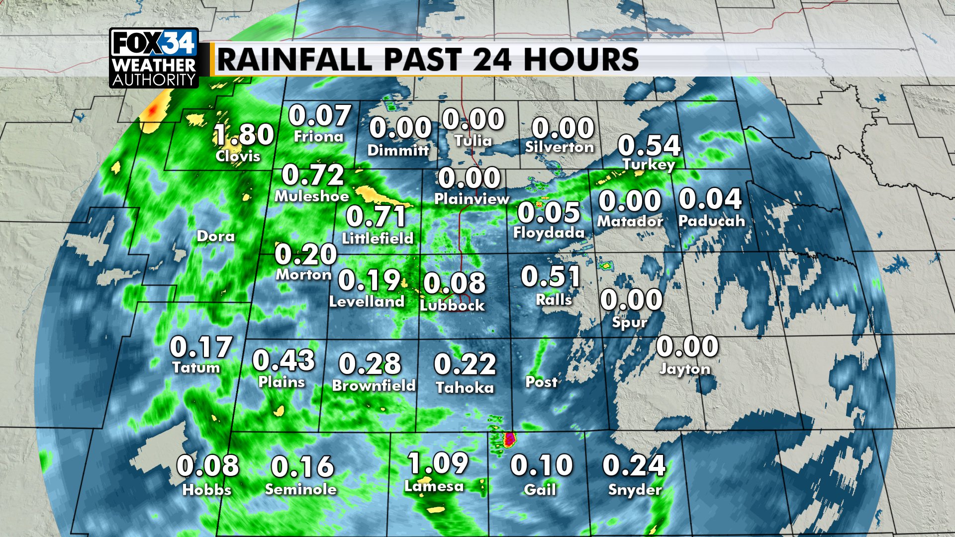
A flood advisory is in effect until 1:30 for about the northwestern quadrant of the area, roughly Lubbock to Muleshoe and Farwell. Radar estimates show a pretty wide swath of 1" to 2" rainfall last three hours in this area.
As for actual measured rain, the Texas Tech Mesonet sites near Reese Center and the Tech campus both show more than 3/4" in an hour. When adding in last night's rain, the Mesonet site near Tech is above 2.8".
We've had several reports of street flooding around Lubbock. Expect this to continue at least next few hours. More rain will fall across the area into this afternoon, at times heavy. The rain chance is a little lower, but still pretty good tonight into tomorrow.
posted 6:18 a.m. Wednesday
GOOD RAINFALL: The heaviest rain in Lubbock County fell across roughly the western half of the county. The Texas Tech Mesonet site near the Tech campus recorded 1.66" of rain. Not too far to the north it was less than 1/10" at the airport.
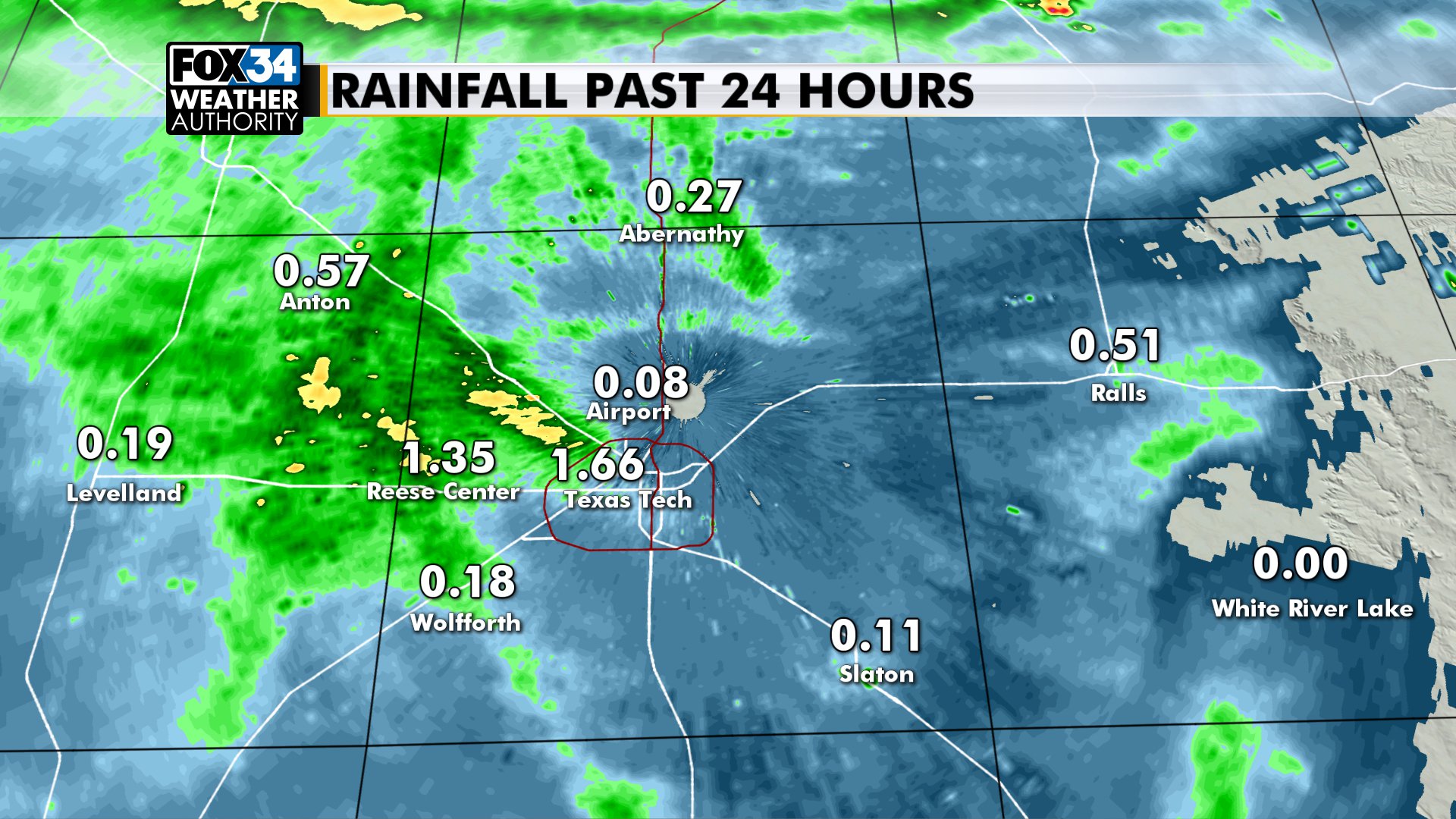
As far as the area the rain was hit-or-miss, with a few more locations getting more than 1/2" after the same thing the night before. These 24-hour totals run through 4 a.m. Wednesday:
TODAY: It'll be cloudy and cool with more rain and storms. The severe threat is low. It won't rain all day. In fact, it may be like the last few days, where you get a brief downpour that quickly adds up. But when it's not raining it'll be cloudy and cool, high near 74, wind NE 5-15mph.
TONIGHT: More showers and storms are possible. By late today into tonight the showers will probably start moving from east to west. This is because the upper-level low will be to our south, in northern Mexico. The flow around it is counter-clockwise.
TOMORROW: It's a lower chance for showers and storms...but still pretty good by West Texas standards. We'll still have a good amount of humidity in the air, which will set up some downpours. It'll be mostly cloudy, high again in the low to mid 70s.
WARMER WEATHER: There still might be a few showers that try to make it into our area Friday, but the rain will probably be well to our south. It'll be near 80 on Friday, then a few degrees warmer Saturday and Sunday beneath a mostly sunny sky. We can't rule out an isolated shower or storm both afternoons this weekend, but the chance is pretty low.
Next week will get warmer, closer to 90 by mid-week.

Have a great day. Rudy will have a full update to the forecast here later today.
-Matt